A Matter of Perspective: A Novel-writing Engineer Takes a Look at the BP Oil Spill
by Mary Anna Evans
Aerial images of oil covering the surface of waters that were once turquoise and clear.
Suffering turtles and water birds, thickly coated with petroleum.
Computer-generated maps purporting to tell us all how bad the situation in the Gulf of Mexico is going to get.
Like the rest of America, I'd seen all those things on my television, but I'm writing a novel set in south Louisiana and the oil spill changes everything. I needed to see the situation with my own eyes. And as a person with a long history in the area, including a brief stint working offshore south of Grand Isle, Louisiana, I needed to see it for myself.
I am the author of a series of mysteries that feature an archaeologist who works in the southeastern United States. Because of the nature of archaeology, it only makes sense that I weave the history of my books' settings into the plot. Because of who I am--a chemical engineer with another degree in physics, who has worked as an environmental consultant--I feel compelled to make sure my fictional world operates properly. My stories are intended to be entertainments, so the history and science are buried deep beneath the surface. I do not believe you will ever pick one up and say, "This reads like a textbook! Yuck!"
On the contrary, the books get great reviews that use words like "fascinating" and compelling," and they've won awards for being fun to read. But they also get good reviews from archaeologists and recognitions like an award from the Florida Historical Society. When I start researching a new story, I'm serious about getting things right, so I go to the source.
When I wrote my fifth book,
Floodgates
, I sold it to my editor by pointing out that I was the author to write a book about post-Katrina New Orleans that would be different from any other, because I have family there and a personal history there that includes a summer working offshore in the Gulf. I also pointed out that, as a licensed engineer, I just
might have something worthwhile to say about the levee failures.
She saw my point and let me write the book. I made much the same argument in favor of my writing my current work-in-progress,
Plunder, a book that features the oil spill catastrophe and, again, she let me write the book. (I love her for being willing to listen to me.)
I figured that something as unprecedented as millions of gallons of oil stretching over a goodly chunk of real estate was something I needed to see with my own eyes before I could write about it intelligently, so I got in my car and drove east until I got to New Orleans.
As I drove across on I-10, the only certain indication of the disaster was periodic announcements on the Panhandle radio stations that scattered tar balls had begun washing up on their beaches, but that they were otherwise fine and open for business. As we all know, by the end of the day, those tar balls had proliferated and morphed into the splattering of oil globs that has at the time of this writing has affected 150 miles of what were the prettiest beaches I've ever seen.
There was an odd moment when I an unmistakable whiff of raw oil seeped into my car cabin. I still don't know how this could be. I was miles inland from the gulf. I spent the next few days after that way down in the Mississippi delta, which is soaked with the stuff just a few miles way from where I was, yet I only detected such a strong scent of oil once. And when I did, there was no oil in sight. Can sea breezes really carry volatile organic compounds so far? Who knows? I'm sure BP doesn't.
Another subtlety I noticed during my drive were two trucks loaded with pipe that was maybe 3 feet in diameter and 20 feet in length. It wasn't a particularly noteworthy sight, except for the police escort, before and after the trucks. There was no wide load sign, and the loads
weren't wide. These escorts weren't the traffic technicians that usually accompany wide loads. They were marked cars with blue lights flashing. Coming home, I saw other trucks carrying the exact same load and being escorted in the exact same way.
I think the pipe was destined for the relief wells being drilled to stop the oil flow, and it was a visual reminder of the enormity of that task. If it takes two trucks and two law enforcement vehicles to transport about 120 feet of pipe, what level of effort will it take merely to get the equipment for those very important wells to the site, much less to drill two such tremendously deep wells? This may be part of the reason we're being told that it will be August before the wells will be finished. Again, who knows? Maybe somebody has to make the pipe before the wells can be completed. It seems to me that someone should have thought of the logistics of this Herculean effort before they ever began drilling at that depth in the first place.
As I neared New Orleans, I drove over swamps and industrial canals and neighborhoods that shouldn't be still trashed from Katrina, but they are. I whizzed past high-rises and the Superdome, and my car climbed high, high above the Mississippi River. Then I hung a left and stopped in Algiers to pick up my cousin Cheryl.
Cheryl grew up on the West Bank and still lives there. She spent several years living in Plaquemines Parish. She'd told me that she thought she could find a friend with a fishing camp we could borrow for the weekend. She could think of three off the top of her head, but she hoped she could get us access to her friend Kenny's camp because it "was nice."
I was expecting something like this:
(Notice how the gorgeous water and sky makes plumbing-free shacks built with scraps of plywood and random pieces of roofing look fairly beautiful.)
Here's the actual camp:
It has four bedrooms, granite countertops, stainless steel professional appliances, and it is beautifully decorated. I looked and looked for something in that "fishing camp" that wasn't nicer than anything I owned. Nope. I was hoping for a relaxing getaway, but I really didn't expect luxury. Score!
On that first evening two exhausted single moms planned our tour of the Mississippi River delta. We did this while sitting on the porch of that magnificent "camp", looking out over the water while we soaked in the jacuzzi, drank beer, and digested a big platter of crawfish. It was truly hard to imagine the devastation that is surely coming to that very spot.
The next morning, we headed south, intending to drive down Plaquemines Highway until it ended in Venice.
To picture this drive, you must first know that the countryside is utterly flat. The difference between water and land in this part of the country is sometimes a mere matter of opinion. If a person digs a ditch, he creates a canal. If he takes the dirt from that ditch and piles it alongside, he creates something that looks to the Louisianan like dry land, so he thinks he might as well build a house on it...and it will be a canalfront house, which is a wonderful thing in this place where everybody loves to fish.
The land on either side of the highway was always low-lying and it was often swampy. The Mississippi River was to our left, and various bays and waterways that are attached to the Gulf were on our right. Waterfronts in both directions are protected by levees, so there was almost always at least one levee within sight. Often those protective piles of dirt rose above us in both directions, a visual reminder that we were following a narrow spit of land as far out to sea as it would take us.
Between our camp in Myrtle Grove and Venice, I had spotted Fort Jackson on the map. It was labeled as a historical site, so I figured it was more than just a campsite named after a long-gone fort. The fort was well-marked, so we had no trouble finding the beautifully constructed old (1822!) masonry building. Unfortunately, it was closed, probably in the wake of Katrina, but we could drive along the access road between the fort and the river. We parked there and got out to explore the area that wasn't closed. Up on the levee was an observation point with a wonderful view of the river and the fort, and of a bayou across the river known as Mardi Gras Bayou that is said to have the oldest place name (1699!) in the Mississippi Valley.
This little tour would have been exactly as I expected it to be, except for the constant thwapping of helicopter blades. Some sort of relief effort was being conducted from the fort property, and many helicopters were taking off in quick succession. They were dangling cables loaded with...something. Dispersant? Cameras? Cheryl and I could hardly contain our curiosity.
We didn't feel comfortable striding into that busy makeshift heliport, so we approached two gentlemen walking across the parking lot. They were wearing protective jumpsuits and had just disembarked from a helicopter that didn't seem to be associated with the others. It turned out that they were with the Fish and Wildlife Commission, and they'd been out doing reconnaissance. They'd come in to deliver an oiled pelican to someone who could help. We asked if they'd seen the spill. They said, yes, and that it was bad. They gestured across the highway and said "It's about fifteen miles over there."
Now the twisty river makes the geography of that area mindbendingly difficult to grasp, but I know one thing. Fifteen miles isn't as far as I'd like it to be. We were well above the end of the road at Venice, and Venice is a long way from the river outlets. I did not like hearing that the oil had come up so far.
The two workers needed to go get some lunch, so we didn't keep them, but we did ask if they knew what the helicopters at Fort Jackson were carrying. "Sandbags," they said. "To fill the gaps between some of the barrier islands."
Now, sand is heavy. The sandbags that those big helicopters were able to carry were relatively small. How many trips will it take to move an appreciable amount of sand by air? Nevertheless, those pilots were giving it a good try. Helicopters came and went so rapidly that the whole area sounded like a war zone.
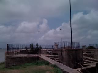
Here's one of the choppers flying over the old fort. You can see the sandbag cable dangling.
And here are some other helicopters, flying over the fort's riverside lookout post, heading off on a mission that doesn't seem to involve sandbags. They were heading across the river, while the sandbag activities seemed to be west of us. I'm thinking they were doing reconnaissance.
When we left Fort Jackson, we headed to the end of the road in Venice. There, we saw a command post sending many workers out into the spill zone. When we got back to the house in Myrtle Grove, we were surprised to see another command post at the marina there. Again, workers arrived by the busload, and a flotilla of boats loaded with passengers were heading out.
Two things crossed my mind. First, all that effort is just not enough. Huge efforts by lots of people will help the situation, but the affected area is unimaginably vast. And second, I was disconcerted to see so much work being done so far north.
We had plans the next day to take a boat out to see the spill. The presence of these workers made me think we wouldn't need to travel nearly as far as I would like.
The next day was my last in Louisiana, so Cheryl's friend Kenny graciously volunteered to take us out on his friend's boat. Because no Louisianan can conceive of a boat in the water without fishing line dangled over the side, we took fishing gear.
It was a gorgeous day, with bright sparkling sunshine and waterbirds going about their business all around us. I know there were fish underwater, because they jumped in the air periodically, but they were all genius fish who knew better than to eat the shrimp I had speared on my hook. To get to our fishing spot, we had traveled down a canal with banks that featured a string of fishing camps that actually
looked like fishing camps, as opposed to the palace where we were sleeping.
There were "For Sale" signs stuck in the muck, in case other people wanted to vacation on the water. (And I mean
on the water.) As best I could tell, the "land" being sold poked out of the water during all phases of the tide, but that was about it. The camps were built on pilings, and you could tell that owners were using various strategies to build up their plots, including dumping oyster shells out in the yard. Those folks either brought the shells in as fill, or they eat a lot of oysters. I, for one, rather like the idea of eating my way to higher ground.
The notion of building on pilings, then building up the land around your home, made me think of Venice. The notion of raising the level of the land with oyster shells made me think of the Native Americans, who were doing that very thing long before Columbus showed up. The notion of sleeping in...no, the notion of
walking in...one of those mildewy cabins gave me the willies, but I did admire the ingenuity of people who built them out of whatever spare building materials they could haul out on their boats. Most of them had air conditioners protruding from the walls, powered by generators that are stored in strongboxes in the yard.
I don't think this ingenuity extended to plumbing. I'm sure they had plenty of water to cook and wash with, because there were various collection systems set up to store rainwater in barrels. However, we saw no pipes beneath the raised buildings to carry sewage away, so I figured we were looking at a latrine situation. One cabin actually had a couple of toilets sitting out in the yard, for all the world to see. We did
not fish anywhere in this area.
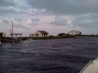
Here is a pic, but understand that my camera seems to magically make them look more beautiful. I wish it worked that way on me.
Do you notice that there is no one visible in this photo? And no visible boats other than our own? Kenny thought this was odd on a weekend. We should have paid attention to this oddity.
We pulled into an open bay and commenced fishing. About the time we got our hooks wet, a Fish and Wildlife boat appeared. This was a negative turn of events, because we'd conferred over whether Cheryl and I should get fishing licenses, and Kenny said he'd never been stopped, not once, in the twenty years since he'd moved to Louisiana. It just didn't make any sense to pay for licenses, when we were only going to fish for an hour or so, then go look for the oil spill.
Bad decision.
The really tragic part of this fishing tale is that, for the only time in my entire life, I actually do have a valid fishing license...in Florida. Another tragic part of this story is that we were fishing in restricted water, so I got two citations. (I have no idea how much these citations are going to cost me, because I'm waiting for my laryngitis to subside before I try to call and ask. I'll also be begging for mercy, because Plaquemines Parish requires you to appear in court for such things. If they don't waive that requirement for this Floridian, I'll be driving back to Louisiana on September 27. Not that returning to the land of good music and beignets is necessarily a bad thing...)
The most tragic part of this, however, is that the restricted water extends so very far. We were in the wrong. We knew there were restrictions and we certainly should have checked for them. (And I shoulda got a local fishing license.) But none of us had any inkling that we were so close to the oil spill.
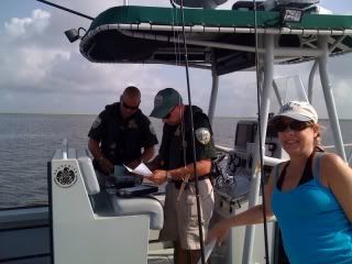
Here are the hardworking and very nice public servants, in the very act of declaring me an interstate criminal. That's Cheryl in the foreground. She's just an
intrastate criminal.
After this, we went back to the camp to drop Cheryl off, because she wasn't feeling well. Then Kenny and I headed back out. We'd confirmed with the Fish and Wildlife officers that the restrictions were just on fishing. We were free to take the boat anywhere we liked, as long as we didn't fish. I have put my criminal days behind me, so I made sure we didn't run afoul of the law again.
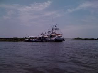
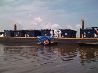
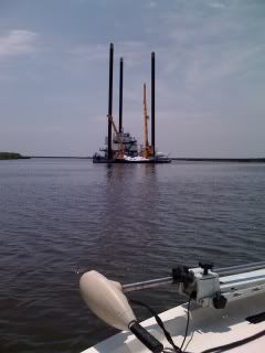
We went down the same canal, heading south. Past the spot where we got our citations, we started seeing moored boats, encircled by boom. We saw skiffs ferrying lifejacketed workers hither and yon. We saw a barge loaded with disposal containers, collecting oily waste. Two big shrimp boats were coming in, and Kenny said that they were fitting those with boom instead of nets, to sweep the oil off the water. Here are a few scenes from the trip down the canal.
Take a good look at those pictures. You can see a large commitment in terms of people and equipment. But then look at the wide open marshland and open water. The area affected is just so huge that it swallows all that effort whole.
We followed the canal until it opened into Barataria Bay. I was still looking all around me for oil, but the boat's sides were clean. (Which was good, since it was borrowed.) And the workboats were all clean, too. Then Kenny said, "Look at the grass."
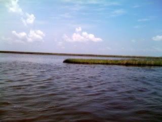
All along the shoreline of the bay, several inches of oil darkened the base of the grasses. That was all, just stained grass, as far as the eye could see. I have no idea how deep into the wetlands that staining extended.
The water of the bay looked clean--no sheens, no free product on the surface. Maybe the oil had come in with the tide, then left as the tide changed, leaving behind a tremendous area of damaged wetland. Or maybe the hardworking cleanup workers had successfully skimmed the bay clean. But you can't skim a swamp, and you can't rip out several parishes worth of fouled grass.
Those grasses hold together the marshes that protect New Orleans and all the people of south Louisiana. They are the nurseries for the seafood we all eat. By diverting the Mississippi and its silty floodwaters, we have starved the marshes, and they are receding. They can no longer withstand the natural battering given by hurricanes. It seems unlikely in the extreme that they can bounce back from this.
I wish I could show you a photo that depicts the enormity of what is happening in the Gulf of Mexico, but you can get those on TV and in the newspaper and on the internet. I can only show you a snapshot of a stained shoreline, taken by an engineer/writer/non-photographer with her cell phone. It's up to you to extrapolate it, imagining square miles of land laid waste.
We headed back to the camp, waving at workers all the way. Now that we'd noticed the staining on the grass, we saw a lot of it as we made our way back up the canal, but eventually it faded away. It was only then that I got a good face-full of the odor of raw oil.
Why hadn't I smelled it when I was looking at it? I have no idea. The chemical engineer in me thinks that the oil is pretty weathered by the time it hits the upper reaches of Barataria Bay. It has had days and miles to lose the volatile fractions that are easiest to smell. Then what was I smelling? I don't know. Maybe the volatile fractions evaporating from the oil that has freshly spewed out of the earth are swept in quickly, by sea breezes. Maybe that explains the odd reports of petroleum odors here in north Florida, presumably far from the action. And maybe it explains the fact that I smelled oil in my car as I drove to New Orleans on I-10, miles inland from the disaster on Pensacola's beaches.
Another thing that strikes this chemical engineer is the problem of separating all that oil from the environment, once it has been released. Chemical engineers take whole classes in separation techniques--distillation, leaching, extraction--but you can't distill the Gulf of Mexico. And I have no idea how you'd extract oil from a living swamp without killing it. It seems that if BP and the agencies regulating them had really considered the consequences of a failure of the blowout preventer, even if the likelihood of such a thing were tiny, then someone somewhere would have designed a system with better contingency planning, in case the unthinkable happened.
Much has been written about the ongoing tragedy in the Gulf of Mexico. What can I add to that mountain of reporting? I think I can offer perspective.
I got in my car last Friday and drove all day without escaping the massive influence of this event. I spent Friday and Saturday watching many dedicated people work feverishly at the Sisyphean task of mitigating the effects of it. We've all watched for nearly two months while hardworking and intelligent people fail to keep the disaster from getting worse. I'm not sure that the human mind is wired to grasp the enormity of the affected area.
Just because aerial photos of the oil spill will fit on your TV screen does not mean that the problem is manageable. We are only human. We can only do so much. This is a sobering thought.
As I sit here typing this narrative, and watching the news, and wondering how bad this thing will get, I feel vulnerable. And I feel small.


